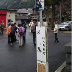
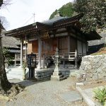
According to the imperial decree promulgated after the Taika-no-Kaishin, the southern limit of Kinai was in Mt. Seyama. The road that crosses the Nabetani mountain pass from Naniwakyo; the capital of that time, leads to Mt. Seyama. In this route you take the bus from the JR Kaseda station to the Shigo bus stop and walk along the Nankaido (National Route no.480) to the Nabetani mountain pass ending at the Chichioni bus stop.
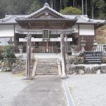
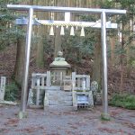
There is an alternative route along the ridge which leads to the Makiosan Sefukuji Temple and is the path of the pilgrimage.
https://kinokawa-ryuiki.com/en/wp-content/themes/wp_nankaido/new_web/tmpl-img/source-bluedot.png
https://kinokawa-ryuiki.com/en/wp-content/themes/wp_nankaido/new_web/tmpl-img/red-dot.png
https://kinokawa-ryuiki.com/en/wp-content/themes/wp_nankaido/new_web/tmpl-img/blue-dot.png
34.403665, 135.511669
34.310276, 135.460154
https://kinokawa-ryuiki.com/en/wp-content/uploads/sites/2/course_08_14n.png
https://kinokawa-ryuiki.com/en/wp-content/uploads/sites/2/course_08_15n.png
https://kinokawa-ryuiki.com/en/wp-content/uploads/sites/2/course_08_16n.png
https://kinokawa-ryuiki.com/en/wp-content/uploads/sites/2/course_08_17n.png
https://kinokawa-ryuiki.com/en/wp-content/uploads/sites/2/course08_1947.png
34.47497849249537,135.5821073295166
34.273788171243176,135.3582608939697
The pink line indicates where the Nankaido used to be. The red line is the walking course.
 Subsidies for Culture and Arts Promotion from the Agency for Cultural Affairs of Japan